
A watch for Oahu, and the models keep nudging Lowell our way
Lowell is a Category 3 hurricane about 405 miles southwest of us, tracking north-northeast toward Kauai. A Tropical Storm Watch is now in effect for East Honolulu, including Hawaii Kai. The official track still keeps the wind field roughly 45 miles short of the site — but that margin has shrunk four advisories in a row, and the rain and surf arrive either way.
Tropical Storm Watch for East Honolulu, which includes Waialae, Aina Haina and Hawaii Kai — tropical storm conditions are possible, not yet expected. A Flood Watch and a High Surf Warning also run for our stretch of coast through 6 PM Tuesday.
Where this stands
Lowell is a major hurricane — 115 mph, 950 mb, with a well-defined eye — and it is aimed at the west end of the chain, not at us. Kauai County is under a Hurricane Warning. The core is forecast to pass near or just west of Niihau tonight and early Tuesday.
What is new this morning is that the 5 AM advisory put Oahu under a Tropical Storm Watch for the first time. A watch means conditions are possible within 12 to 24 hours. It is not a forecast that they will happen here, and the numbers behind it are genuinely modest: the Hurricane Center puts Honolulu's chance of seeing sustained tropical-storm-force wind at 10 percent, against 83 percent for Lihue.
So the honest summary of the wind story is that we are close to the edge of something large, on the good side of it, with a modest chance of being wrong about that.
The 45-mile gap
Lowell's tropical-storm-force winds reach out about 175 miles from the center. At its closest approach to us — around 2 to 4 AM Tuesday, with the center some 220 miles west-northwest — that field reaches to within roughly 45 miles of The Ivy and stops.
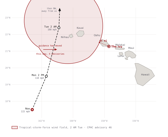
Forty-five miles is not much of a cushion on a system this size. It is about one and a half of the eastward corrections the Hurricane Center has already made this weekend.
What the best models say
This is the part worth reading twice, because the model guidance is not neutral about which way the error is likely to fall.
Lowell is being steered by a cut-off upper-level low north of Hawaii. That is a notoriously difficult steering pattern, and the guidance has responded by shifting east on four consecutive advisories — about 30 nautical miles each time. The Hurricane Center has followed it east each time rather than holding its ground.
More to the point: the models sitting on the eastern edge of the spread — the side that brings Lowell toward Oahu — are the ones the Hurricane Center itself describes as typically better-performing.
| Model | What it is | Where it sits |
|---|---|---|
| HCCA | HFIP Corrected Consensus — bias-corrected blend, usually the best track aid on the board | Eastern edge |
| GDMI | Google DeepMind ensemble mean — the AI guidance that has outperformed on track this season | Eastern edge |
| HAFS-A / -B | NOAA's hurricane-specific high-resolution models | Eastern edge |
| GFS, TVCN | American global model and the simple multi-model consensus | Western / center |
Positions within the guidance envelope as characterized in CPHC forecast discussions 43 through 46, 6–7 September. "Eastern edge" means closer to Oahu.
That is an unusual and uncomfortable alignment. Normally a forecast sitting at the edge of the guidance can be discounted a little as an outlier. Here the outliers are the aids with the best track record, they all agree with each other, and the official forecast has been walking toward them for 24 hours. The Hurricane Center has been explicit about what that implies, writing that any further eastward shift could require a Tropical Storm Warning for Oahu later today.
One useful piece of context: the same discussion notes the guidance falls apart beyond two days, when Lowell interacts with an upper trough. That disagreement is about where Lowell goes after it has passed us, and it does not affect anything on this page. The near-term track — the part that matters to us — is well modeled. It is simply modeled with a bias in a direction we would rather it did not have.
What happens here, and when
| When | Wind | Rain chance | Wording |
|---|---|---|---|
| Today | E 16–24 g29 | 98% | Frequent showers, thunderstorms |
| Tonight | SE 16–31 | 100% | Tropical storm conditions possible |
| Tuesday | S 9–31 | 78% | Tropical storm conditions possible |
| Tuesday night | S 6–9 | 54% | Scattered showers |
| Wednesday | ESE 8 | 55% | Clearing |
Speeds in mph, sustained, with gusts after g. NWS Honolulu point forecast for the grid cell containing 428 Kawaihae Street, read Monday 6 AM.
Note the wind direction swinging from east through southeast to south overnight. That is Lowell's circulation taking over from the trades, and it matters here for a practical reason: it puts wind and rain on elevations that normally sit in the lee. Doors, lanais and drains that never take weather on a trade-wind day will take it tonight.
Rain and surf are the certain part
Whatever the wind does, two things are already happening and do not depend on the track shifting at all.
The Flood Watch carries 4 to 8 inches for Oahu, with isolated totals to 10, running through 6 PM Tuesday. Our own grid cell is forecast around 1 to 2 inches today and another 2 to 3 tonight. At 18 feet of elevation on the flat near the marina, that is ponding, drainage and water finding the low door — not surge. Storm surge for Oahu is forecast at up to one foot, which is a tide-and-timing problem rather than an inundation problem.
A High Surf Warning is in effect for our south-facing shores through 6 PM Tuesday. This is the hazard most likely to actually hurt someone this week, and it is entirely avoidable: nobody on the shoreline, the marina walls or the beach parks until it lifts.
One further item that does not usually appear in these briefings: the Hurricane Center notes a few tornadoes are possible across the main islands outside Kauai today and tonight. The odds at any one address are very low, but it is worth knowing the interior-room drill is the same one you would use for the wind.
Prepare for the rain, watch the track. Lowell's official forecast passes us to the west with about 45 miles to spare, and the odds of tropical-storm-force wind at the site are only around 10 percent. The rain, the surf and the Flood Watch are not conditional on any of that.
But the best-performing guidance has been on the side that closes the gap, and the Hurricane Center has moved toward it four advisories in a row. Treat a Tropical Storm Warning for Oahu today as a live possibility, and get the outdoor work done this morning while it is still pleasant to do.
Checklist
This morning While conditions allow
Advisories are running every three hours, with intermediate updates in between. Official sources are NWS Honolulu and the Central Pacific Hurricane Center. Text OMG Hawaii any time today or tonight.
Situational awareness, not an official weather product. Storm position, track, wind radii and wind-speed probabilities are CPHC advisory 46, 7 September 5 AM HST; site figures are the NWS Honolulu point forecast for the same location; model characterizations are from CPHC forecast discussions 43 through 46. For evacuation guidance and shelter status, rely on the City and County of Honolulu Department of Emergency Management. If the timestamp line in the banner turns red, that text has not been verified against the feed and should be read as written Monday morning.