
No offshore event yet, a long heat wave now, and an El Niño that cuts both ways
Where the season actually stands going into offshore wind season. We have not had a Santa Ana or a Diablo wind event worth the name, and the record El Niño makes a below-normal number of them likely. But the fuels are drying fast under this heat: a large fire is possible through Thursday, Friday is the day wind and humidity could align badly, and then it breaks.
Hello all. This is a season check-in rather than a warning — nothing is threatening any of your communities today. But we are at the point in the calendar where the season changes character, and this particular week has a sharp edge on it, so it is worth laying out what we are actually looking at.
The short version: the fire season to date was mild by the numbers, but this heat wave is drying the fuels toward near-record values for the date and a large fire is possible through Thursday. Friday is the day to watch, and then it breaks. Beyond that, the offshore wind season that normally does the damage looks likely to be quieter than usual, and the thing most worth preparing for this winter is probably water rather than fire. None of that means relax. It means knowing which risk to spend your attention on, and when.
Colorado is the exception on every count in that paragraph, and after the summer you had there it gets a section of its own below.
We still have not had a real offshore event
That is the honest headline, and it is unusual to be able to say it on the fourth of October. Through all of September, onshore flow prevailed across Southern California. There were gusty periods in the eastern Sierra and the deserts, but as Predictive Services put it in their monthly outlook, “no major wind events” arose. In Northern California the strongest northerly push came on 13–14 September and favoured the Sacramento Valley and the adjacent foothills — a real event, but a local one.
One correction to make, because it matters for how you read Saturday: we did get a modest offshore push this weekend. Easterly winds of 15 to 25 mph with gusts to 40 to 50 mph overlapped the heat warnings Saturday morning in inland Orange County, San Diego County and the Inland Empire. That is not a Santa Ana event in the sense this group uses the term. It is also, as it turns out, enough.
Looking ahead, we do not see a significant offshore pattern setting up in the next week to ten days. Beyond that the honest answer is that nobody does — but the seasonal signal, which we get into below, argues for fewer of these events than normal rather than more.
The heat is the story this week
An anomalous ridge is parked over the West and it is not in a hurry. Peak heating was Saturday, with temperatures 15 to 20°F above normal and the hottest valleys around 107°F. Downtown Los Angeles and Long Beach both hit 103°F on 2 October and broke records doing it; San Jose reached 106°F. Extreme Heat Warnings run through 8 October across the Southern California coast and valleys, and Heat Advisories cover the Sacramento and San Joaquin valleys, the Bay Area, the Central Coast and northwestern California through the 7th.
The part that matters for your buildings is the overnight lows. Interior minimums are holding in the 60s and low 70s, which means the building does not shed its heat load before the next day starts. That is the mechanism that turns a hot week into a medical problem — the same one we went through in July. Residents on diuretics, anticholinergics or beta blockers are the ones to check on first, and the second-floor west-facing rooms are where it shows up first.
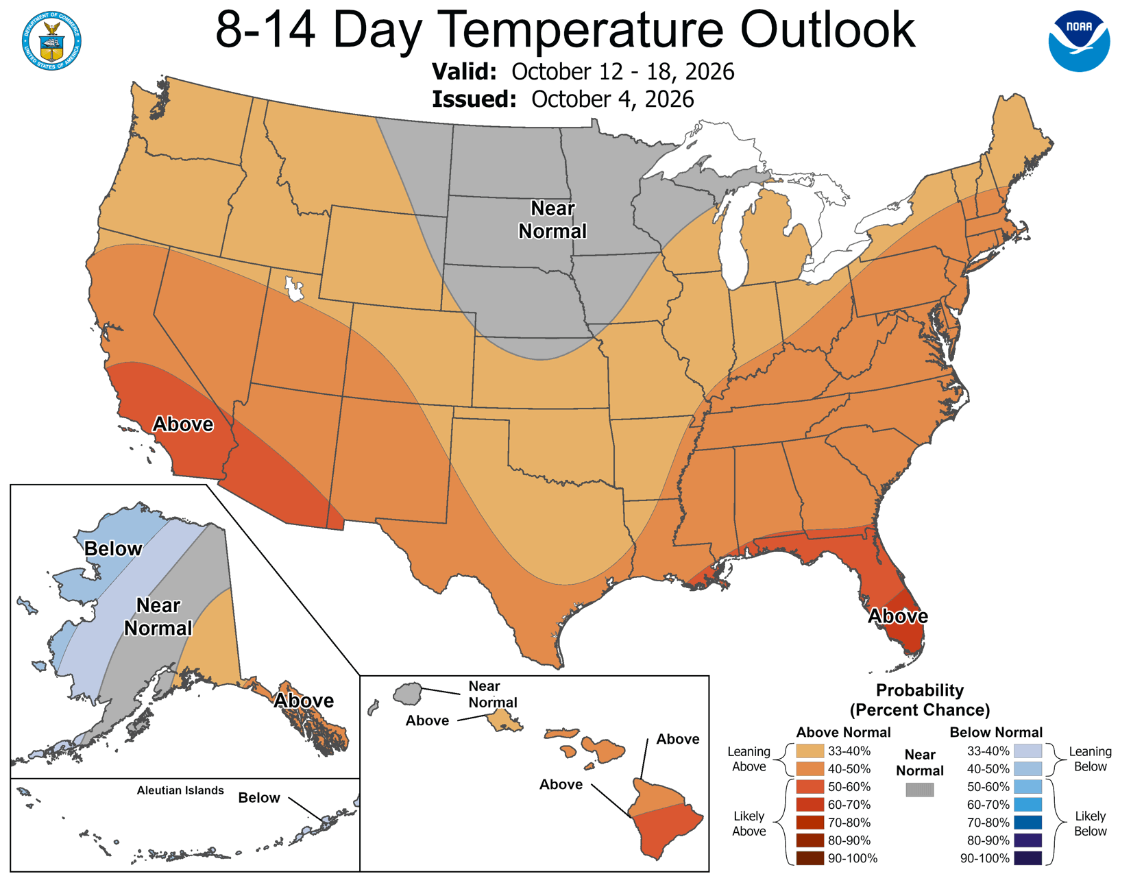
The trough that arrives late Friday ends this episode: cooler, more humid, through next weekend. It does not end the warm pattern. The 8–14 day outlook already has California back in the likely-above-normal category for 12–18 October. So expect a break, not a turn — one cool weekend inside an autumn that stays warm.
The fuels are drying fast, and that is this week's story
The monthly outlook and the seven-day outlook do not say the same thing right now, and the seven-day is the one to act on. It is worth understanding both, because the gap between them is the situation.
The season to date has been genuinely mild. The standard measure of how much heat a fire can put out — which is really a measure of how hard it would be to stop — ran at or below normal through most of peak season, aside from a couple of brief spikes. There were not enough sustained hot, dry stretches this summer. Heavy dead fuels came through September with moisture near to above normal, helped by the Labor Day rain from Hurricane Marie. That is real, and it is why 2026 has been quieter here than the last few years.
This heat wave is undoing it quickly. Predictive Services now has dead fuel moisture dropping noticeably through most of the next seven days. Put in plain terms, the forecast is this: across most of the state the fuels are heading into the driest 20% of conditions ever recorded for this point in the calendar, and along the coast and in the Coast Range into the driest 10% as next week goes on. That is near record territory for early October. The fuels are described as unusually flammable and trending toward critically flammable. South Ops puts it plainly: hot and very dry conditions will cause a significant decrease in dead fuel moisture through Thursday.
The burn periods are getting long. The burn period is the stretch of each day when conditions will actually carry a fire — normally it shuts down in the evening when the air cools and the humidity comes back. This week it is running unusually long for October, with heavier smouldering overnight. That matters most in the thermal belts — the band on mid-slopes where warm air sits overnight while colder, denser air drains past it into the valley below. Those slopes never get the humidity recovery the valley floor gets, so a fire that reaches one keeps working through the night instead of laying down. Overnight recovery this week is expected to be localised: high mountain basins, valley bottoms, and ground very near the coast. Everywhere else, assume the fire does not get its usual night-time break.
The brush and the grass are at seasonal minimums. Shrub moisture sampling has run near normal over the past 30 days — a little below in some places, a little above in others — but minimum values have likely been reached across many areas, which puts the woody fuels in a flammable to critically flammable state regardless of how the sampling reads against normal. Grasses and forbs are cured to mostly cured, and cured grass is what carries fire during dry, breezy periods.
So the seasonal answer and the this-week answer genuinely differ. Here is how the next ten days break down.
The window. Treat it as live.
Dead fuel moisture falling noticeably, fuels heading into the driest 10 to 20% of early Octobers on record, long burn periods and limited overnight recovery outside the basins and the coast. A large fire is possible on any afternoon in this stretch — the Bouquet Fire is what that looks like. The number of new fires is still expected to be low, so this is about how the one you get behaves, not how many there are.
The hinge, and the day to watch.
Westerlies increase ahead of an approaching trough. Friday carries the risk of wind and relative humidity aligning badly — the wind arrives with the front before the moisture does, over fuels that have had five days of record heat worked into them. If one day in this period produces a problem, this is the most likely candidate.
It breaks.
Temperatures cool and humidity increases behind the trough, with a large increase in dead fuel moisture by next weekend. South Ops expects the large fire threat to drop substantially. This is the recovery, and it is the window to do anything you have been putting off.
Saturday outside Santa Clarita is the proof
The Bouquet Fire started just before 3:20 PM Saturday near Bouquet Canyon Road and Quarry Road in the Angeles National Forest, northeast of Santa Clarita. It was reported at 20 acres. Within a few hours it was a thousand. As of this morning it is 1,048 acres and 40% contained, with evacuation orders on three zones and warnings on nine more.
No Oakmont community is threatened — the nearest are well clear and there is no action to take. I am including it because of what it demonstrates. That fire ran on cured grass and brush, in record heat, with a weak offshore component, and it did it on the first day of this heat wave — before most of the drying the next seven days will do. South Ops expects the same possibility to stand through Thursday. That is the shape of the risk right now.
The season to date has been one of the mildest in years. That tells you nothing about this week. Through Thursday the fuels are drying toward near-record values for the date, Friday is the day wind and humidity could align badly, and then it breaks — cooler, wetter, threat down substantially into next weekend. Run the next four days as live, use the break to get ahead of offshore wind season, and treat the winter as a flood and access problem rather than a fire one.
Drought in California: much shallower than it looks
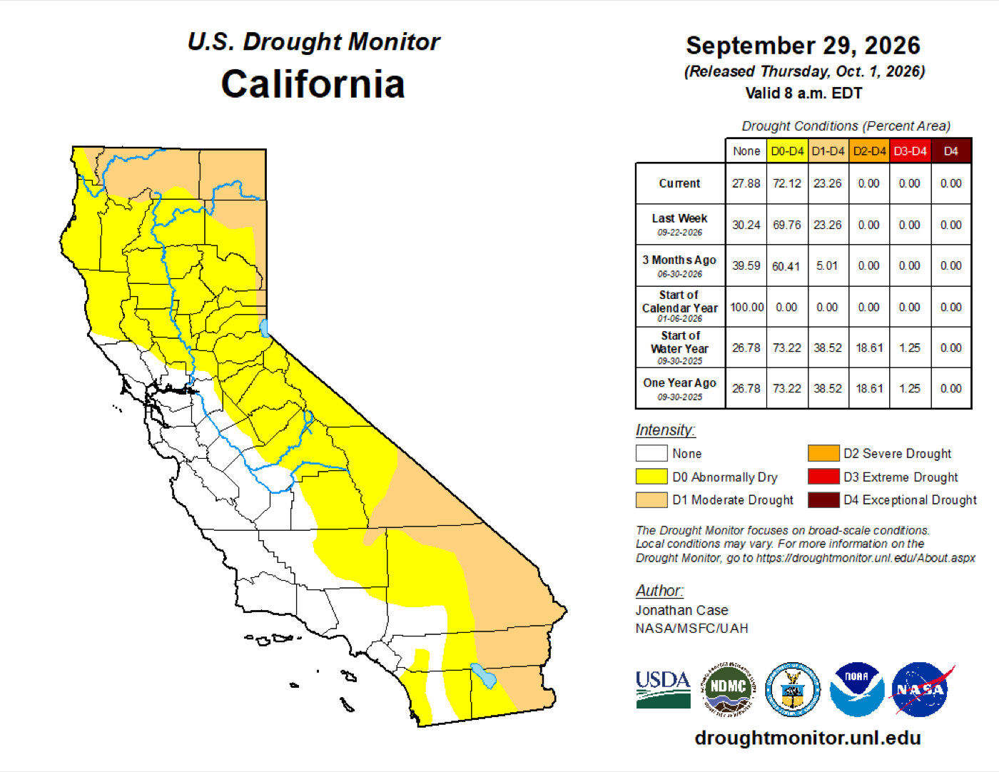
About 72% of California is abnormally dry and 23% is in moderate drought. Those are the headline numbers, and on their own they sound bad. The number that matters more is the one that is missing: zero percent of the state is in severe, extreme or exceptional drought. Not one acre.
A year ago to the day, 18.6% of California was in severe drought or worse and 1.25% was in extreme drought. At the start of this calendar year the state was 100% drought-free. So what has happened in 2026 is a steady, shallow drying — real, driven by last winter's rainfall deficits and an anomalously warm spring, with a weak monsoon that could not undo it, but nowhere near the depth of the last few years. California is the lightest ground in the West right now. Oregon, Idaho, Utah and — as the next section gets into — Colorado are carrying the extreme and exceptional categories.
Hawaiʻi is in better shape still. There is no drought anywhere on the island chain, and the abnormally dry area actually shrank through September. Two tropical systems — Hurricane Lowell past Kauaʻi at the start of the month and Hurricane Nolo past the Big Island at the end — put well above normal rain across most of the islands.
Colorado is the exception, and Aspen Acres is why that matters
Six Oakmont communities sit in Colorado — Thornton, Cherry Hills, Mountain View, Castle Rock, Colorado Springs and Pueblo — and the Colorado picture is close to the inverse of the California one. It is the part of the portfolio where this year's drought is genuinely deep, and it is the part that has already had its fire.
What Aspen Acres actually did
The Aspen Acres Fire started on 29 June, human-caused and still under investigation, and ran through Custer, Pueblo and Huerfano counties. It finished at 102,004 acres — the seventh-largest wildfire in Colorado's recorded history — and destroyed 851 structures, including about 337 homes, 254 of them in Pueblo County. At its peak roughly 3,800 homes were under evacuation order, affecting more than 11,000 people. The orders ran through Beulah, Colorado City, Wetmore and the surrounding country west and southwest of Pueblo rather than the city itself.
It was not an isolated event. Colorado burned around 235,000 acres in 2026, after going into the season on one of the lowest snowpacks on record. The governor had warned in April of a significantly increased risk along the Front Range, and that forecast verified.
The lesson was about smoke, not flame
This is the part worth carrying forward. Only Pueblo was anywhere near the fire, and even there the flame front stayed out in the country. But every one of the six Colorado communities was affected, because smoke does not respect the distance that makes an evacuation map reassuring.
Air Quality Health Advisories covered Pueblo and El Paso counties — two of your sites — along with Fremont, Teller, Huerfano, Custer, Lincoln and Elbert. The smoke then went north up the corridor. Denver metro recorded unhealthy air, and on one day in early July Denver had the worst air quality of any city in the United States, ahead of Los Angeles. That is Thornton, Cherry Hills, Mountain View and Castle Rock, none of which were within sixty miles of a flame.
For a senior living population that is the whole exposure. Residents with COPD, asthma, heart failure or any cardiac history respond to fine particulate at levels well below what a healthy adult notices, and the response shows up as emergency department visits rather than as anything dramatic on site. A fire 100 miles away with no evacuation order attached to it is still an operational event at all six communities, and this summer proved it.
Where Colorado stands now
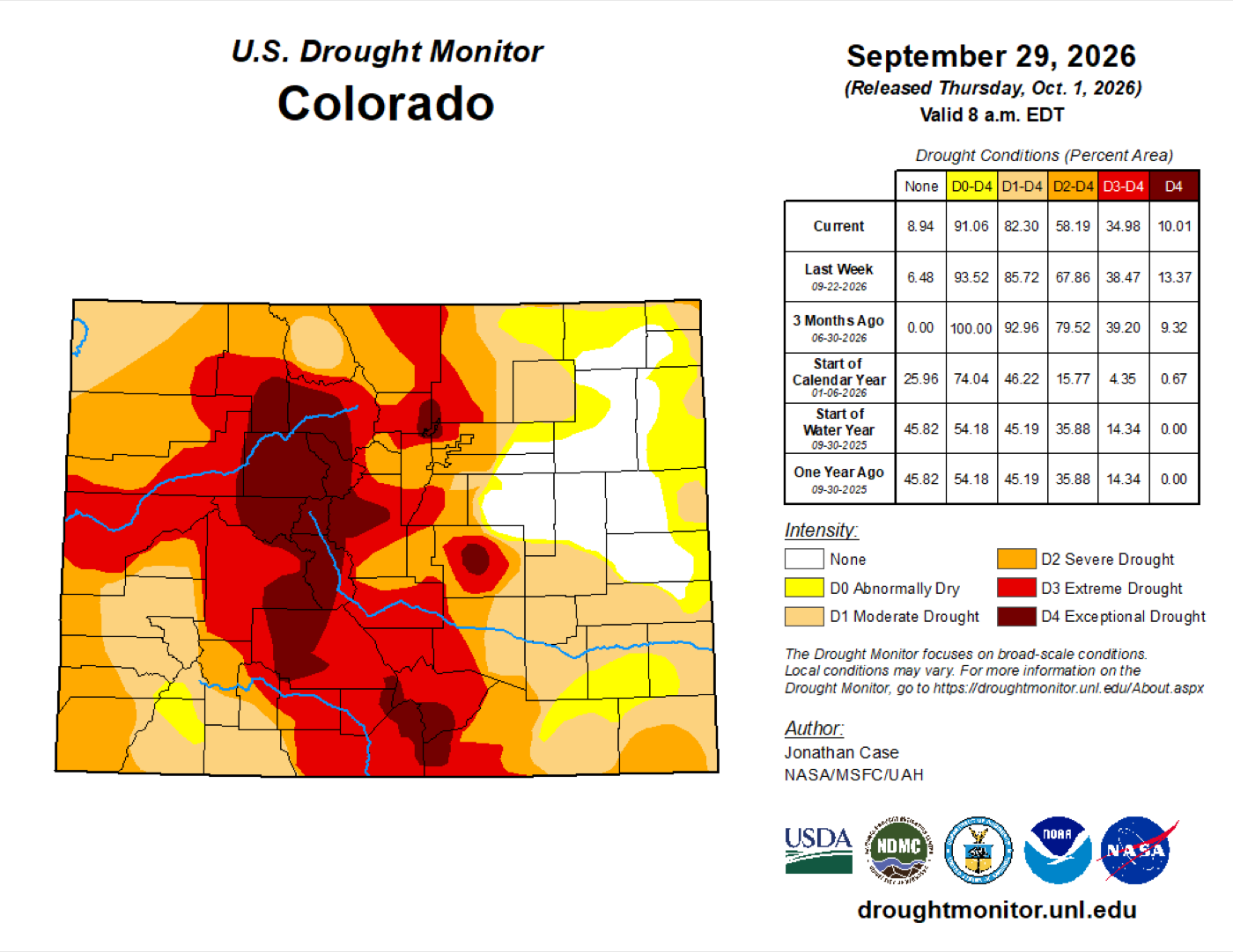
Much worse than California, and it is not close. Statewide, 82% of Colorado is in moderate drought or worse, 35% is in extreme drought or worse, and 10% is in exceptional drought — the top category. California, by comparison, has nothing at all in severe drought. The deepest ground is central and western Colorado; the Front Range corridor where your communities sit runs through the severe-to-extreme band.
It is also improving. A year ago the state had no exceptional drought at all, so this is a bad year rather than a bad decade — and September's storms pulled the numbers back from where they stood three months ago. Every category is better than it was last week.
What the rest of the year looks like there
Better than the summer, with one caveat. The Rocky Mountain outlook carries normal significant fire potential from October through January. September brought above-normal rain across most of the area, which moderated fuel moisture at most elevations and started live fuels trending up; curing and dormancy have actually been slowed by the moisture. Fire danger indices rose during the dry spells but never stayed critical for long.
El Niño helps here too, and specifically where you need it. A typical El Niño autumn and winter brings wetter weather to the southern tier of the Rocky Mountain area — south of Interstate 70, which is Castle Rock, Colorado Springs and Pueblo — while the northern portion runs warmer with about average precipitation. Drought is expected to improve across the area through the period.
The caveat is wind. Autumn and winter bring stronger storm systems to the Front Range, and after any stretch of warm, dry weather there will be brief windows of elevated fire potential. Predictive Services expects these to be short — generally a day or two at a time — but short is not the same as harmless.
It is worth being blunt about this, because the calendar misleads people in Colorado. Aspen Acres was the biggest fire of the year, but the most destructive fire in the state's history was the Marshall Fire, and it burned on 30 December. It took 1,084 homes in Louisville, Superior and unincorporated Boulder County in a single afternoon, on 6,219 acres, driven by downed power lines and gusts over 100 mph across cured grass with no snow on the ground. That is roughly 6% of the acreage of this summer's fire and more than three times the homes — in December, in built-up suburbs, in the same Front Range corridor as Thornton, Mountain View and Cherry Hills.
So the Colorado fire season does not end when the Colorado summer does. A warm, dry, snowless stretch plus a downslope wind event is the dangerous combination there, and it is available in any month. El Niño reduces the odds of that setup this winter by putting snow on the ground earlier. It does not remove it.
El Niño: where it stands, and why the models keep changing their minds
NOAA has an El Niño Advisory in force and the event is still strengthening. The latest diagnostic discussion puts the Niño-3.4 index at +1.8°C, Niño-3 at +2.5°C and Niño-1+2 at +3.4°C, with subsurface anomalies above +10°C at depth. The Climate Prediction Center now gives better than a 90% chance of a very strong event through winter 2026–27, and a 75% chance this becomes the strongest El Niño since records begin in 1950. Most of the model guidance, domestic and international, has it at number one outright.
Sources: CPC ENSO Diagnostic Discussion, issued 10 September 2026 · National Significant Wildland Fire Potential Outlook, issued 1 October 2026 · South Ops monthly and seasonal outlook, issued 30 September 2026 · Predictive Services 7-day significant fire potential and fuels discussions, 4 October 2026
That brings us to the forecasting problem several of you have asked about, and it is a real one. For the past couple of months, our 7-to-10-day runs have repeatedly shown a weak tropical system coming ashore in Southern California — and then, as the date gets closer, the pattern reverts to something ordinary. As recently as yesterday, two models had a tropical storm into Southern California next weekend. Today that signal is gone.
This is not the models malfunctioning. A very strong El Niño warms the eastern Pacific and makes that basin hyperactive, which is exactly what we have seen — Marie, Lowell, Nolo, Odalys, Polo, and Rachel sitting southwest of Baja as I write. So at long range the models correctly sense that there is a lot of tropical moisture out there. What they cannot resolve at ten days is the steering: whether any given system recurves out to sea, runs into Mexico, or threads the needle north. As the run gets shorter and the steering becomes resolvable, the answer almost always turns out to be “not us.” Marie over Labor Day was the exception, not the rule, and even that was an indirect moisture impact rather than a landfall.
How to use that: when you see a tropical system on a long-range graphic, treat it as a statement about the season, not about next weekend. Current odds of another round of tropical moisture reaching California later this month run around 5 to 10%. Low, not zero, and we will tell you if it firms up.
What the El Niño signal means for your footprint
Here is the part worth taking away. For the Oakmont portfolio — 119 communities across California, Colorado, Nevada and Hawaiʻi — this El Niño does not point one direction. It points one way on the mainland and the opposite way in the Pacific.
The mainland gets wetter, Hawaiʻi gets drier. A schematic of the CPC winter outlook over the four states where you have communities. The strongest wet signal in the country sits over Southern California, where most of your portfolio is. The Pacific signal runs the other way entirely. Odds from the NOAA CPC seasonal outlook for Dec–Jan–Feb 2026–27, issued 17 September 2026. Shapes are schematic, not to scale.
California, Nevada and Colorado: wetter, and starting late
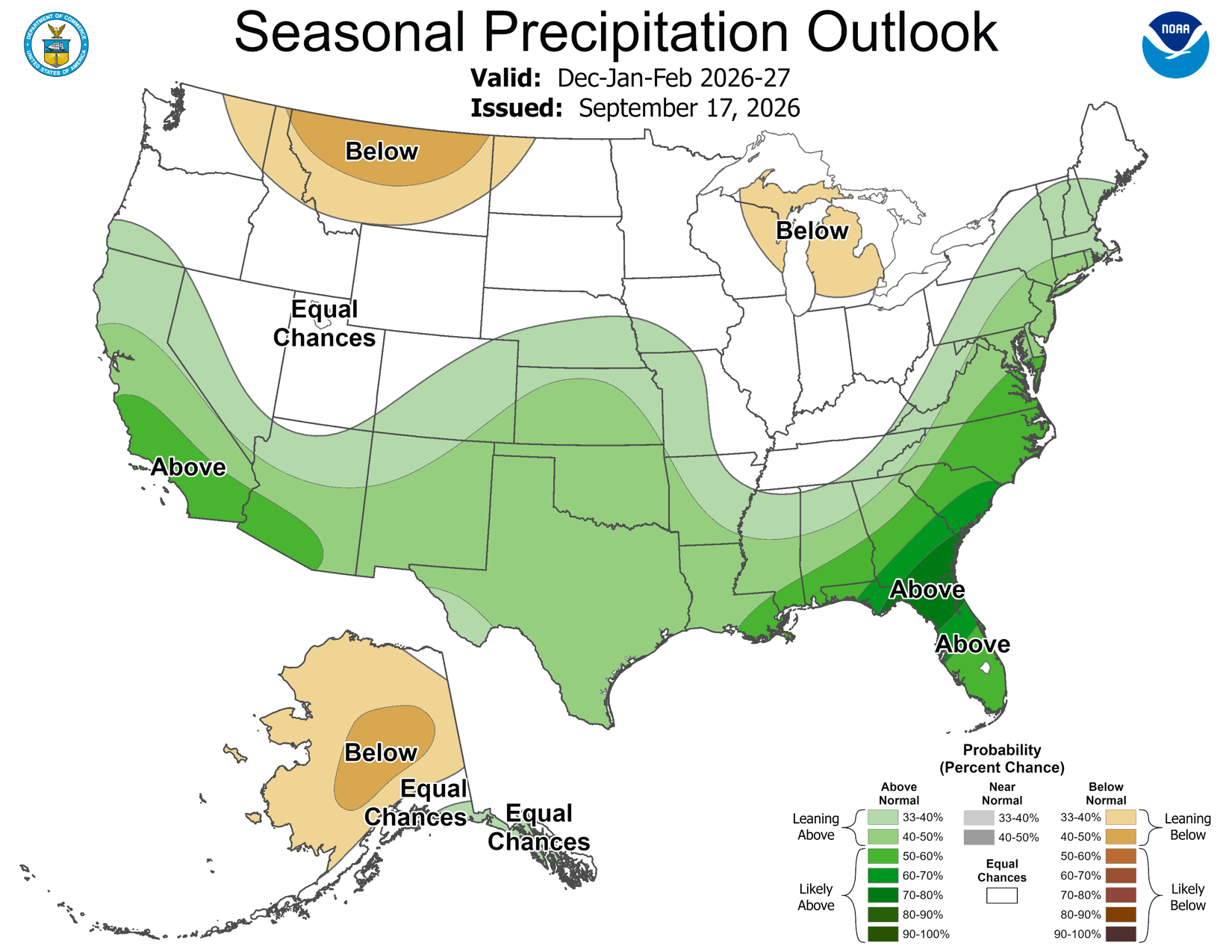
The seasonal outlook favours above-normal precipitation across all three, strongest in the south. Southern California carries 50 to 60% odds of a wetter-than-normal winter — among the strongest signals anywhere in the country — central California 40 to 50%, and the far north only 33 to 40%. Nevada sits around 40 to 50%; Colorado 33 to 40%, with the better odds falling south of Interstate 70, which is the half of your Colorado footprint that needs them most.
Timing matters as much as amount. The El Niño signal ramps slowly, and the wet period is expected to arrive from December onward, peaking January through March. October is forecast warmer and drier than normal; November is the transition month. So a dry October tells you nothing about this winter, and anyone who concludes in three weeks that the forecast busted will be reading it wrong.
Hawaiʻi: the signal runs backwards
El Niño does not bring Hawaiʻi a wet winter. It brings the opposite. Kona lows — the systems that deliver most of the islands' wet-season rain — become less frequent, and the outlook favours below-normal rainfall from October through December and into early spring 2027. Historically, roughly 70% of El Niño onsets are followed by drought during the Hawaiian wet season.
For fire, that creates a specific and slightly counterintuitive problem. This year's very active tropical season left the islands greener than normal, with abundant herbaceous growth and a lot of downed vegetation and storm debris. All of that is fuel once it cures. The largest Hawaiʻi fire in September was about 100 acres of grass on Maui on the 26th, run by downslope winds off Hurricane Nolo. Predictive Services carries Hawaiʻi at normal fire potential through January but flags exactly this concern for later in the period, as the leeward sides dry out.
For Hawaiʻi Kai specifically, nothing changes this month. What changes is that the back half of winter is the period to watch there, and it is the one place in the portfolio where the drought risk goes up this season rather than down.
What this means for offshore wind season
Offshore winds are what drive the region's largest and most destructive fires, and they do it when they arrive ahead of the seasonal rain. We are entering that window now. Two things are true about it this year.
First, a word about the phrase you will see on every agency product this month. Predictive Services rates normal significant fire potential for Northern California and Hawaiʻi from October through January, and near normal for Southern California. That sounds like an all-clear and it is not one. The rating measures expected large-fire activity against what is typical for those months — and October is the busiest month in the whole outlook period. Normal for October in Northern California means four large fires. November means one. December and January together average less than one. So “normal” in October and “normal” in December describe completely different levels of activity, and the first one is the month we are in.
The Southern California rating carries a second piece of fine print worth knowing. South Ops wrote that were it not for the early-October heat, they would have gone below normal for the South Coast this month, on the strength of the rain from Marie. The only reason the rating is near normal rather than below is the weather we are living through right now. The rating already has this heat wave inside it.
The season should be quieter
- El Niño favours storm tracks that come in off the Pacific rather than dropping south over the interior — and it is the interior high that builds Santa Anas.
- Predictive Services expects a below-normal number of offshore wind events this season as a result.
- Fuel dryness ran at or below normal through most of peak season, so October started from an unusually good place.
- Significant rain is expected to arrive earlier than usual, which shortens the window.
And it only takes one
- “Below normal” still means a couple of events, and the early-season ones are explicitly expected.
- A good starting point can be spent in a week. The fuels are heading for the driest 10% of early Octobers on record along the coast, right now.
- Fine fuels are cured statewide and the brush has reached its seasonal minimum.
- October is the month with the best chance of breezy, dry northerly wind events in Northern California.
- Every destructive wind-driven fire in this state's history happened in a season someone described as quiet beforehand.
The seasonal outlook tells you how to allocate attention across three months. It tells you nothing about any particular afternoon. Both of those statements are worth holding at once, and the second one is the one that gets people hurt when it is forgotten.
Where we go from here
Nothing in this briefing asks you to do anything today. What it asks is that you do not read a mild season as a finished one. Run the next four days as live, and then use the cool, humid stretch behind Friday's trough — while the weather is working for you rather than against you — to review your fire procedures properly: the evacuation plan, the transport agreements, the receiving sites, the generator, and in Colorado the smoke plan. Those are the things that are hard to do under pressure and easy to do next weekend.
We are watching Friday closely and will send something if the wind and humidity look like aligning. After that we go back to the usual trigger: we send a briefing when an offshore event appears in a timeframe worth acting on, not on a calendar. Between briefings, text OMG South, OMG North or OMG Hawaii with anything at all, including a read on one specific property.
WCG would like to thank all of you for being Fire Aware. We are heading into offshore wind season, and at the same time we are watching how this El Niño shapes both the fire picture and the water picture. Those two things are going to pull in opposite directions this year, and we will keep you ahead of both.